


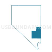
Precinct 4 - Pioche, Lincoln County, Nevada
About
Outline

Summary
| Unique Area Identifier | 615363 |
| Name | Precinct 4 - Pioche |
| County | Lincoln County |
| State | Nevada |
| Area (square miles) | 2,906.64 |
| Land Area (square miles) | 2,906.00 |
| Water Area (square miles) | 0.64 |
| % of Land Area | 99.98 |
| % of Water Area | 0.02 |
| Latitude of the Internal Point | 38.26403420 |
| Longtitude of the Internal Point | -114.52109660 |
Maps


Graphs
Select a template below for downloading or customizing gragh for Precinct 4 - Pioche, Lincoln County, Nevada


Neighbors
Neighoring Voting District (by Name) Neighboring Voting District on the Map
- Garrison 16 Voting District, Millard County, UT
- Milford 2 Unincorporated Voting District, Beaver County, UT
- Modena Voting District, Iron County, UT
- Precinct 1 - Alamo, Lincoln County, NV
- Precinct 3 - Panaca, Lincoln County, NV
- SUNNYSIDE PRECINCT 13, Nye County, NV
- WP COUNTY MAILING VTD 10, White Pine County, NV
- WP LUND VTD 8, White Pine County, NV
- WP SNAKE VALLEY VTD 9, White Pine County, NV
Top 10 Neighboring County Subdivision (by Population) Neighboring County Subdivision on the Map
- Ely CCD, White Pine County, NV (5,941)
- Pioche CCD, Lincoln County, NV (2,684)
- Milford-Minersville CCD, Beaver County, UT (2,678)
- Alamo CCD, Lincoln County, NV (1,398)
- Beryl-Newcastle CCD, Iron County, UT (1,313)
- Lund CCD, White Pine County, NV (538)
- Baker CCD, White Pine County, NV (363)
- Duckwater CCD, Nye County, NV (228)
- Garrison-Sevier Lake CCD, Millard County, UT (160)
Top 10 Neighboring Place (by Population) Neighboring Place on the Map
Top 10 Neighboring Unified School District (by Population) Neighboring Unified School District on the Map
- Iron School District, UT (46,163)
- Nye County School District, NV (43,946)
- Millard School District, UT (12,503)
- White Pine County School District, NV (10,030)
- Beaver School District, UT (6,629)
- Lincoln County School District, NV (5,345)
Top 10 Neighboring State Legislative District Lower Chamber (by Population) Neighboring State Legislative District Lower Chamber on the Map
- Assembly District 36, NV (59,012)
- Assembly District 35, NV (51,108)
- State House District 72, UT (40,624)
- State House District 73, UT (34,070)
- State House District 68, UT (31,934)
Top 10 Neighboring State Legislative District Upper Chamber (by Population) Neighboring State Legislative District Upper Chamber on the Map
Top 10 Neighboring 111th Congressional District (by Population) Neighboring 111th Congressional District on the Map
- Congressional District 3, UT (966,232)
- Congressional District 2, UT (890,993)
- Congressional District 2, NV (836,562)
Top 10 Neighboring Census Tract (by Population) Neighboring Census Tract on the Map
- Census Tract 9702, White Pine County, NV (5,919)
- Census Tract 1103, Iron County, UT (3,508)
- Census Tract 9742, Millard County, UT (3,037)
- Census Tract 1002, Beaver County, UT (2,811)
- Census Tract 9501, Lincoln County, NV (2,684)
- Census Tract 9502, Lincoln County, NV (2,661)
- Census Tract 9601, Nye County, NV (2,330)
- Census Tract 9701, White Pine County, NV (1,882)